By Alasdair Crosby.
THERE was once a violent storm… and don’t we just know about violent storms in Jersey?
This storm, however, was in the year 1356. Here is the story — history as it probably never was, but should have been:
‘There used to exist, in what is now a spot out to sea in the northern part of St Ouen’s Bay, an old manor house and its surrounding Fief, known as La Brecquette. Its location is now an offshore reef, but it was then part of the “Vallée de L’Etacq” and was one of the most fertile areas of the parish. It was sheltered on the north and east by a forest of mature oaks.
One night, there was a terrible storm. There was no sea wall then, and nothing to stop the sea from rolling in to flood the shoreline. In the middle of the night, the Seigneur, Jean Wallis, woke, full of fear at what seemed like the imminent destruction of his home. So he immediately fled by horse, galloping inland as fast as could.
When he reached the safety of high ground, he drew rein to look back and must have been aghast at what he saw in the light of dawn: there was visible no manor house, no fief, no farm, no fields, no woods – just heavy seas and crashing waves in a suddenly much extended bay.
Wallis wanted to make quite sure that this sort of thing would never happen to him again. So he built a new home right in the middle of the Island, on the border of St Lawrence and St John, as far away as possible from any coastline; his new home is now known as Les Saints Germains.
This story must be true, because some of the big blocks of stone from the manor walls can still be seen on the beach at low tides, as can also be seen vestiges of the roads leading to La Brecquette, as well as tree-stumps of what had been its surrounding oak woods.’
Over the centuries, there have been attempts to try to find some historical truth behind this legend, but there is little, if any, corroborative evidence for it.
However, as a result of an excavation in 2007 by the archaeological section of the Société Jersiaise, organised by the late Brian Phillipps, and following a subsequent investigation by him, there is a suggestion that there is indeed some historical basis to the legend.
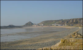
In what is now a potato field, near the car park by La Saline slipway at the end of the lane called Le Chemin de La Brecquette (the name is possibly something of a give away) stands the remains of a small stone structure. At one time it was probably used as a boathouse or shed.
It seemed a very old building, and he wondered if it could have been part of the manor. Nobody knew anything about it, so he got the Société’s archaeological section to do an excavation there.
Thy found that the upper part of the walls were post Mediaeval, possibly early 18th Century, but they interpreted the foundation and lowest portion of the walls as much earlier, possibly 14th Century. There was also a trace of an interior wall that had been ‘robbed’ – its stones dismantled and taken away.
This building, he stressed, was definitely not the Manoir de La Brecquette, although the foundations and lowest stonework did date from the right period; it might, however, have been part of the estate.
So where was the main building? The site of the legendary manor was said to be out nearly half a mile out to sea, northwest of La Saline, but that story is simply unbelievable.
*The remains of oak trees visible at some very low tides are some 6,500 years old and not a mere 650 years old.
*The remains of apparent stone roadways and ‘walls’ still visible have everything to do with making solid and safe pathways for horses and carts to collect vraic, and nothing to do with roads to a submerged manor.
*If there had been such a catastrophic storm, the authorities seem to have taken a very laid-back attitude to the sudden loss of all this rich and productive land. There is no independent contemporary written record of valuable land being lost in this way. Very stoic, the St Ouennais — was this an incident best ignored and not worth recording?
*There are no remains of wells or of other buildings on the foreshore; these would certainly have existed if the drowned area had been as agriculturally productive as legend recounts.
*There is no reputable account or any physical sign that sea levels have altered significantly over the past 1,000 years.
There is, in fact, only one account of the ‘drowned manor story’ in the historical record. In 1669 the Seigneurs of St Ouen and Vinchelez de Haut were in conflict over wreckage rights. A ship had been wrecked in St Ouen’s Bay, and the exact dividing line between the two Fiefs was in question – both Seigneurs wanted the loot for themselves.
At a court hearing, one witness, Philip Mahaut (aged 80), testified how, in his youth, he had been shown at the time of an extremely low tide the ruins of the Manoir de la Brecquette, clearly marked with the boundary marks of Vinchelez.
His testimony, if accepted, would have helped the Seigneur in his claim, but it is likely that this witness had been ‘nobbled’ or primed in advance.
The entire legend of La Brecquette seems to have originated from his rather suspect testimony.
Another, possibly more credible witness, Elie de Heaume, said that a stream, Le Douet, marked the boundary between the two fiefs and the old manor house was not out to sea, but on land, a little to the north of the stream.
Le Douet is still in existence today – it emerges on to the beach at La Saline, and just to the north of it is a field, La Haussière – and that is where the ruins excavated by the Société are located.
The excavation trenches showed a layer of sea sand more than 3ft deep had blown in and settled since mediaeval times. So possibly the ‘fact’ of the legend was a sandstorm, rather than a flood.
After the excavation, an aerial survey of the area, dating from 1933, was found. This showed the crop-marked outline of a building complex (invisible to an observer on the ground) in the western corner of the field. This indicated that a group of buildings had once been located there, near the still-existing ‘boatshed’ building.
Although a geophysical survey of the area was commissioned, there were no significant features detected. So Mr Phillipps walked over the ground with an auger (a 4ft-long hand-held hole-borer).
By this means, in the area indicated by the crop marks in the aerial survey, he found, submerged in the sandy soil, large chunks of solid granite – possibly the undressed foundation stones of buildings that had once stood there.
From this evidence, he suggested that there had been a sandstorm that covered the fields of this farmhouse in the 14th Century. Afterwards, the owner – perhaps Jean Wallis – thought it would be too difficult and unprofitable to continue farming this land. Fortunately for him, he had another holding at Les Saints Germains so he decided to dismantle his home and re-erect it on his other land in St Lawrence.
Dressed stone was an expensive commodity, so he decided to re-use the stones he already had, including probably the granite arches and other familiar features that meant ‘home’ to him.
There would have been no point in moving the undressed foundation stones, which were left behind. Although he removed the interior wall in the ‘boatshed’, he left the lower part of the exterior walls as a sea defence and a visible sign that the land of La Brecquette was still his property.
During the demolition, the clay bonding between the stones fell to the ground; this residue has been preserved above the ‘foundation stones’ in the form of a greyish soil, more nutritious for future crops than the sandy soil elsewhere, and so the pattern of the outline of the building was preserved; it was still visible from the air 600 years later.
It is the only indication that there was a mediaeval farmstead located in the area claimed to have been the location of La Brecquette in that 1669 Inquiry.
The land is good potato land – currently under this year’s crop, so better, in short, to let buried stones lie.
And Les Germains? It was said to be in ruins in the 17th Century, and was subsequently demolished. The present building there dates only from the 19th Century.
The Wallis family? The name does crop up in late mediaeval Jersey history, but during the Wars of the Roses, they chose the wrong side at the wrong time, supporting Lancastrians when the Yorkists were in the ascendant. One of the Wallis family was killed at the Battle of Barnet, and later their land was sequestered by the Crown.
But why the name ‘La Brecquette?’ In the Jersey context it means a gap between two pieces of higher ground. But the area around La Saline is really quite flat. Unless, of course, once upon a time there was a violent storm that dramatically re-arranged the shape of the landscape…
With thanks to the JEP for permission to reprint this story